
Kork topographic map
Interactive map
Click on the map to display elevation.
About this map
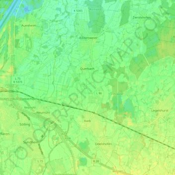
Name: Kork topographic map, elevation, terrain.
Location: Kork, Kehl, Ortenaukreis, Bade-Wurtemberg, Allemagne (48.55554 7.83907 48.60553 7.94622)
Average elevation: 138 m
Minimum elevation: 128 m
Maximum elevation: 146 m
Other topographic maps
Click on a map to view its topography, its elevation and its terrain.
Odelshofen
Allemagne > Bade-Wurtemberg > Ortenaukreis > Kehl
Odelshofen, Kehl, Ortenaukreis, Bade-Wurtemberg, Allemagne
Average elevation: 138 m