
Make a donation
Gear up for your next adventure:
As an Amazon Associate, this site earns from qualifying purchases at no extra cost to you.
Ober-Roden topographic map
Click on the map to display elevation.
Make a donation
Gear up for your next adventure:
As an Amazon Associate, this site earns from qualifying purchases at no extra cost to you.
Ober-Roden
Ober-Roden liegt südöstlich von Frankfurt am Main und nordöstlich von Darmstadt, ca. 20 km südlich von Offenbach am Main auf dem 50. Breitengrad. Die Ortschaft liegt auf einer Höhe von 140 m ü. NHN an dem Flüsschen Rodau.
Make a donation
Gear up for your next adventure:
As an Amazon Associate, this site earns from qualifying purchases at no extra cost to you.
About this map
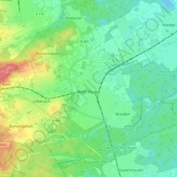
Name: Ober-Roden topographic map, elevation, terrain.
Location: Ober-Roden, Rödermark, Landkreis Offenbach, Hessen, Deutschland (49.94652 8.80037 50.00887 8.85354)
Average elevation: 149 m
Minimum elevation: 123 m
Maximum elevation: 205 m
Make a donation
Gear up for your next adventure:
As an Amazon Associate, this site earns from qualifying purchases at no extra cost to you.
Other topographic maps
Click on a map to view its topography, its elevation and its terrain.
Make a donation
Gear up for your next adventure:
As an Amazon Associate, this site earns from qualifying purchases at no extra cost to you.