
Crestwood Estates topographic map
Interactive map
Click on the map to display elevation.
About this map
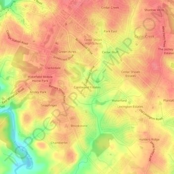
Name: Crestwood Estates topographic map, elevation, terrain.
Average elevation: 213 m
Minimum elevation: 165 m
Maximum elevation: 235 m
Other topographic maps
Click on a map to view its topography, its elevation and its terrain.
Athens-Clarke County Unified Government
United States > Georgia > Athens-Clarke County > Athens-Clarke County Unified Government
Athens-Clarke County Unified Government, Athens-Clarke County, Georgia, United States
Average elevation: 219 m