
Thank you for supporting this site ❤️
Make a donation
Make a donation
Gear up for your next adventure:
As an Amazon Associate, this site earns from qualifying purchases at no extra cost to you.
Nax topographic map
Click on the map to display elevation.
Thank you for supporting this site ❤️
Make a donation
Make a donation
Gear up for your next adventure:
As an Amazon Associate, this site earns from qualifying purchases at no extra cost to you.
About this map
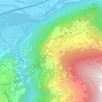
Name: Nax topographic map, elevation, terrain.
Location: Nax, Mont-Noble, Hérens, Wallis, 1973, Switzerland (46.20677 7.40503 46.24677 7.44503)
Average elevation: 990 m
Minimum elevation: 490 m
Maximum elevation: 1,907 m
Thank you for supporting this site ❤️
Make a donation
Make a donation
Gear up for your next adventure:
As an Amazon Associate, this site earns from qualifying purchases at no extra cost to you.