
Ashley National Forest topographic map
Interactive map
Click on the map to display elevation.
About this map
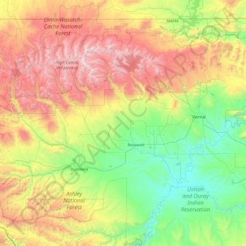
Name: Ashley National Forest topographic map, elevation, terrain.
Location: Ashley National Forest, Utah, United States of America (39.86976 -111.03895 40.96517 -109.24133)
Average elevation: 2,248 m
Minimum elevation: 1,405 m
Maximum elevation: 4,088 m
Other topographic maps
Click on a map to view its topography, its elevation and its terrain.
Jackson Hole
United States of America > Utah
Jackson Hole, Grand County, Utah, United States of America
Average elevation: 1,313 m
Wasatch Range
United States of America > Utah > Sandy
Wasatch Range, Sandy, Salt Lake County, Utah, United States of America
Average elevation: 1,880 m
Hyrum
United States of America > Utah > Hyrum
Hyrum, Cache County, Utah, United States of America
Average elevation: 1,442 m
Mount Nebo
United States of America > Utah
Mount Nebo, Juab County, Utah, United States of America
Average elevation: 3,115 m
Towne Center Apartments
United States of America > Utah > Herriman > Towne Center Apartments
Towne Center Apartments, Herriman, Salt Lake County, Utah, 84096, United States of America
Average elevation: 1,467 m
Moon Apartments
United States of America > Utah > Provo > Moon Apartments
Moon Apartments, Provo, Utah County, Utah, 84601, United States of America
Average elevation: 1,421 m
(West) Mueller Park
United States of America > Utah > Bountiful
(West) Mueller Park, Bountiful, Davis County, Utah, United States of America
Average elevation: 1,473 m
Linden Circle
United States of America > Utah > Holladay
Linden Circle, Holladay, Salt Lake County, Utah, 85412, United States of America
Average elevation: 1,365 m
Eddie Kay
United States of America > Utah > Millcreek
Eddie Kay, Millcreek, Salt Lake County, Utah, 84117, United States of America
Average elevation: 1,331 m
Wendover
United States of America > Utah > Wendover
Wendover, Tooele County, Utah, 84083, United States of America
Average elevation: 1,369 m
Salt Point
United States of America > Utah
Salt Point, Emery County, Utah, United States of America
Average elevation: 1,811 m
Twin Peaks
United States of America > Utah > Midvale
Twin Peaks, Midvale, Salt Lake County, Utah, 84107, United States of America
Average elevation: 1,337 m