
Make a donation
Gear up for your next adventure:
As an Amazon Associate, this site earns from qualifying purchases at no extra cost to you.
Friedberg (Hessen) topographic map
Click on the map to display elevation.
Make a donation
Gear up for your next adventure:
As an Amazon Associate, this site earns from qualifying purchases at no extra cost to you.
Friedberg (Hessen)
Friedberg liegt etwa 30 km nördlich von Frankfurt am Main in der Wetterau. Die Stadt befindet sich etwas oberhalb der Einmündung der Usa in die Wetter. Die Stadtkirche im Zentrum der Stadt liegt auf einer Höhe von 159 Metern über dem Meeresspiegel. Teile der Friedberger Gemarkung erstrecken sich bis in den Taunus auf den Steinkopf mit seiner Höhe von 518 Metern.
Make a donation
Gear up for your next adventure:
As an Amazon Associate, this site earns from qualifying purchases at no extra cost to you.
About this map
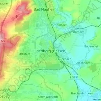
Name: Friedberg (Hessen) topographic map, elevation, terrain.
Average elevation: 164 m
Minimum elevation: 117 m
Maximum elevation: 284 m
Make a donation
Gear up for your next adventure:
As an Amazon Associate, this site earns from qualifying purchases at no extra cost to you.