
Make a donation
Gear up for your next adventure:
As an Amazon Associate, this site earns from qualifying purchases at no extra cost to you.
Kace topographic map
Click on the map to display elevation.
Make a donation
Gear up for your next adventure:
As an Amazon Associate, this site earns from qualifying purchases at no extra cost to you.
About this map
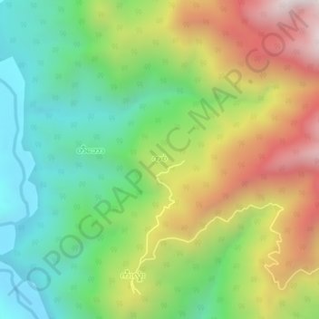
Name: Kace topographic map, elevation, terrain.
Location: Kace, Matupi Township, Mindat District, Chin, Myanmar (21.70781 93.36002 21.74781 93.40002)
Average elevation: 958 m
Minimum elevation: 458 m
Maximum elevation: 1,703 m
Make a donation
Gear up for your next adventure:
As an Amazon Associate, this site earns from qualifying purchases at no extra cost to you.
Other topographic maps
Click on a map to view its topography, its elevation and its terrain.
Matupi Township
Myanmar > Chin > Mindat District
Agriculture is the most essential and profitable industry in the Matupi Township, employing more than 90% of the population. Common crops include rice, wheat, corn, millet, pulses, oilseeds, coffee, oranges, damson, potatoes, and natural fibres. However, Matupi still depends on the import of rice supplies from…
Average elevation: 940 m