
Terenten topographic map
Interactive map
Click on the map to display elevation.
About this map
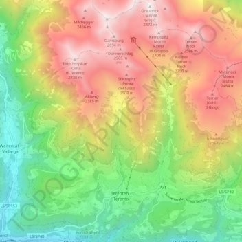
Name: Terenten topographic map, elevation, terrain.
Location: Terenten, Pustertal, Bozen, Trentino-Südtirol, Italien (46.81489 11.73151 46.88817 11.83416)
Average elevation: 1,681 m
Minimum elevation: 743 m
Maximum elevation: 2,797 m
Other topographic maps
Click on a map to view its topography, its elevation and its terrain.
Donnerschlag
Italien > Trentino-Südtirol > Bozen > Terenten
Donnerschlag, Terenten, Pustertal, Bozen, Trentino-Südtirol, Italien
Average elevation: 2,373 m