
Make a donation
Gear up for your next adventure:
As an Amazon Associate, this site earns from qualifying purchases at no extra cost to you.
Export topographic map
Click on the map to display elevation.
Make a donation
Gear up for your next adventure:
As an Amazon Associate, this site earns from qualifying purchases at no extra cost to you.
Export
Export is characterized by a varied terrain that reflects its location in the Allegheny Plateau region. The borough sits at an average elevation of around 1,122 feet (342 meters) and features rolling hills and valleys typical of southwestern Pennsylvania's topography. The surrounding landscape is marked by gentle slopes and a mix of wooded areas and open fields, providing a picturesque setting that transitions into more rugged terrain as you move toward the nearby hills. The area is also influenced by local waterways, which have carved out small valleys and contribute to the region's rich biodiversity.
Make a donation
Gear up for your next adventure:
As an Amazon Associate, this site earns from qualifying purchases at no extra cost to you.
About this map
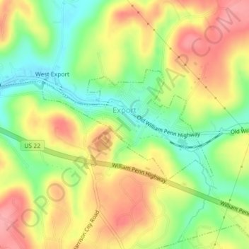
Name: Export topographic map, elevation, terrain.
Average elevation: 342 m
Minimum elevation: 289 m
Maximum elevation: 393 m
Make a donation
Gear up for your next adventure:
As an Amazon Associate, this site earns from qualifying purchases at no extra cost to you.
Other topographic maps
Click on a map to view its topography, its elevation and its terrain.
Moween
United States > Pennsylvania > Westmoreland County > Loyalhanna Township
Average elevation: 319 m
Alice
United States > Pennsylvania > Westmoreland County > Mount Pleasant Township
Average elevation: 450 m
Alverton
United States > Pennsylvania > Westmoreland County > East Huntingdon Township
Average elevation: 361 m
Make a donation
Gear up for your next adventure:
As an Amazon Associate, this site earns from qualifying purchases at no extra cost to you.
Fort Allen
United States > Pennsylvania > Westmoreland County > Hempfield Township
Average elevation: 347 m
Forbes Road
United States > Pennsylvania > Westmoreland County > Salem Township
Average elevation: 366 m
Whites Hill
United States > Pennsylvania > Westmoreland County > Hempfield Township
Average elevation: 324 m
Make a donation
Gear up for your next adventure:
As an Amazon Associate, this site earns from qualifying purchases at no extra cost to you.
Jones Mills
United States > Pennsylvania > Westmoreland County > Donegal Township
Average elevation: 523 m
Oak Grove
United States > Pennsylvania > Westmoreland County > Ligonier Township
Average elevation: 414 m
Squirrel Hill
United States > Pennsylvania > Westmoreland County > Saint Clair Township
Average elevation: 354 m
Roaring Run Natural Area
United States > Pennsylvania > Westmoreland County > Donegal Township
Average elevation: 759 m
Make a donation
Gear up for your next adventure:
As an Amazon Associate, this site earns from qualifying purchases at no extra cost to you.
Hopewell
United States > Pennsylvania > Westmoreland County > Donegal Township > Hopewell
Average elevation: 542 m
Stanton Heights
United States > Pennsylvania > Westmoreland County > New Stanton > Stanton Heights
Average elevation: 327 m
Paintersville
United States > Pennsylvania > Westmoreland County > New Stanton > Paintersville
Average elevation: 324 m
Midway
United States > Pennsylvania > Westmoreland County > Hempfield Township > Midway
Average elevation: 330 m
Make a donation
Gear up for your next adventure:
As an Amazon Associate, this site earns from qualifying purchases at no extra cost to you.
Fellsburg
United States > Pennsylvania > Westmoreland County > Rostraver Township
Average elevation: 333 m
Keystone State Park
United States > Pennsylvania > Westmoreland County > Derry Township
Average elevation: 352 m
Reagantown
United States > Pennsylvania > Westmoreland County > South Huntingdon Township
Average elevation: 398 m
Basforth Acres
United States > Pennsylvania > Westmoreland County > Hempfield Township
Average elevation: 379 m
Make a donation
Gear up for your next adventure:
As an Amazon Associate, this site earns from qualifying purchases at no extra cost to you.