Geolocate

Mullion topographic map

Click on the map to display elevation.

About this map

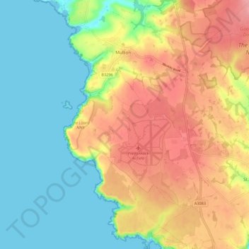
Name: Mullion topographic map, elevation, terrain.

Location: Mullion, Cornwall, South West England, England, United Kingdom (49.97248 -5.26869 50.04157 -5.18845)

Average elevation: 45 m

Minimum elevation: 0 m

Maximum elevation: 103 m

Other topographic maps

Click on a map to view its topography, its elevation and its terrain.

Darite

United Kingdom > England > Cornwall > St Cleer

Average elevation: 236 m

Pengold

United Kingdom > England > Cornwall > St Gennys

Average elevation: 135 m

Port Isaac

United Kingdom > England > Cornwall

Average elevation: 43 m

Gunnislake

United Kingdom > England > Cornwall

Average elevation: 109 m

Bridgetown

United Kingdom > England > Cornwall

Average elevation: 93 m

Pengrugla

United Kingdom > England > Cornwall > Pengrugla

Average elevation: 66 m

Minions

United Kingdom > England > Cornwall > Minions

Average elevation: 265 m

Gwinear

United Kingdom > England > Cornwall

Average elevation: 65 m

Lerryn

United Kingdom > England > Cornwall

Average elevation: 60 m

Gear up for your next adventure:

Altimeter Barometer Watches - Outdoor watches with built-in sensors to track altitude changes and weather shifts
🕶️Polarized Sunglasses - UV protection sunglasses for outdoors
🔋Solar Power Banks - Solar chargers for outdoors
🧢Wide Brim Sun Hats - Maximum coverage for the face and neck while out in the open
🐍Australian Snake Bite Kits - Specific pressure immobilization bandages for Australian venomous snakes

As an Amazon Associate, this site earns from qualifying purchases at no extra cost to you.