
Make a donation
Gear up for your next adventure:
As an Amazon Associate, this site earns from qualifying purchases at no extra cost to you.
Moose Harbour topographic map
Click on the map to display elevation.
Make a donation
Gear up for your next adventure:
As an Amazon Associate, this site earns from qualifying purchases at no extra cost to you.
About this map
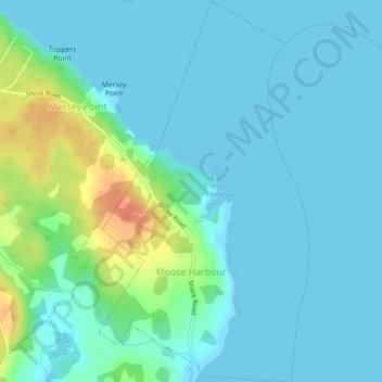
Name: Moose Harbour topographic map, elevation, terrain.
Average elevation: 9 m
Minimum elevation: -1 m
Maximum elevation: 43 m
Make a donation
Gear up for your next adventure:
As an Amazon Associate, this site earns from qualifying purchases at no extra cost to you.
Other topographic maps
Click on a map to view its topography, its elevation and its terrain.
Mersey River
Canada > Nova Scotia > Queens County > Kejimkujik National Park of Canada
Average elevation: 93 m
Cape Split
Canada > Nova Scotia > Queens County > Kejimkujik National Park of Canada
Average elevation: 130 m
Make a donation
Gear up for your next adventure:
As an Amazon Associate, this site earns from qualifying purchases at no extra cost to you.