
Make a donation
Gear up for your next adventure:
As an Amazon Associate, this site earns from qualifying purchases at no extra cost to you.
Mohanchatti topographic map
Click on the map to display elevation.
Make a donation
Gear up for your next adventure:
As an Amazon Associate, this site earns from qualifying purchases at no extra cost to you.
About this map
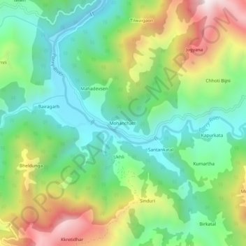
Name: Mohanchatti topographic map, elevation, terrain.
Average elevation: 744 m
Minimum elevation: 416 m
Maximum elevation: 1,347 m
Make a donation
Gear up for your next adventure:
As an Amazon Associate, this site earns from qualifying purchases at no extra cost to you.
Other topographic maps
Click on a map to view its topography, its elevation and its terrain.
Elephant Pound Rajaji National park Uttrakhand
India > Uttarakhand > Yamkeshwar
Average elevation: 455 m
Elephant Pound Rajaji National park Uttrakhand
India > Uttarakhand > Yamkeshwar
Average elevation: 455 m
Elephant Pound Rajaji National park Uttrakhand
India > Uttarakhand > Yamkeshwar
Average elevation: 455 m
Make a donation
Gear up for your next adventure:
As an Amazon Associate, this site earns from qualifying purchases at no extra cost to you.
Elephant Pound Rajaji National park Uttrakhand
India > Uttarakhand > Yamkeshwar
Average elevation: 455 m
Elephant Pound Rajaji National park Uttrakhand
India > Uttarakhand > Yamkeshwar
Average elevation: 455 m