
Make a donation
Gear up for your next adventure:
As an Amazon Associate, this site earns from qualifying purchases at no extra cost to you.
Meinerswijk topographic map
Click on the map to display elevation.
Make a donation
Gear up for your next adventure:
As an Amazon Associate, this site earns from qualifying purchases at no extra cost to you.
About this map
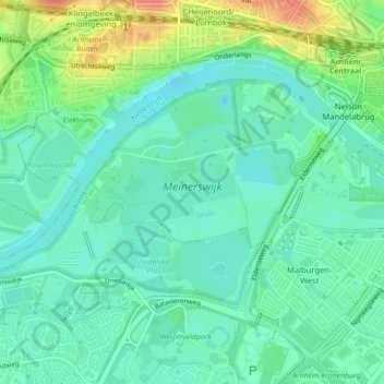
Name: Meinerswijk topographic map, elevation, terrain.
Average elevation: 15 m
Minimum elevation: -2 m
Maximum elevation: 49 m
Make a donation
Gear up for your next adventure:
As an Amazon Associate, this site earns from qualifying purchases at no extra cost to you.
Other topographic maps
Click on a map to view its topography, its elevation and its terrain.
Arnhem
Nederland > Gelderland > Arnhem
De stad telt meerdere theaters, waarvan het Stadstheater Arnhem het belangrijkste is. Dit theater doet dienst als schouwburg en als concertzaal. Musis Sacrum op het Velperplein is het vaste concertgebouw van Phion, het orkest van Gelderland en Overijssel. Theater aan de Rijn, KAB Posttheater, Huis van Puck,…
Average elevation: 24 m
Make a donation
Gear up for your next adventure:
As an Amazon Associate, this site earns from qualifying purchases at no extra cost to you.