
Bellevue topographic map
Interactive map
Click on the map to display elevation.
About this map
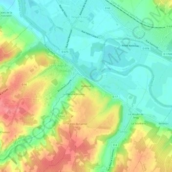
Name: Bellevue topographic map, elevation, terrain.
Average elevation: 93 m
Minimum elevation: 62 m
Maximum elevation: 138 m
Other topographic maps
Click on a map to view its topography, its elevation and its terrain.
Pièces du Carroir
France > Centre-Val de Loire > Loir-et-Cher > Seigy
Pièces du Carroir, Seigy, Romorantin-Lanthenay, Loir-et-Cher, Centre-Val de Loire, France métropolitaine, 41110, France
Average elevation: 103 m
Les Falloirs
France > Centre-Val de Loire > Loir-et-Cher > Seigy
Les Falloirs, Seigy, Romorantin-Lanthenay, Loir-et-Cher, Centre-Val de Loire, France métropolitaine, 41110, France
Average elevation: 96 m
Le Moulin de Seigy
France > Centre-Val de Loire > Loir-et-Cher > Seigy > Le Moulin de Seigy
Le Moulin de Seigy, Seigy, Romorantin-Lanthenay, Loir-et-Cher, Centre-Val de Loire, France métropolitaine, 41110, France
Average elevation: 94 m
Moulin de Roche
France > Centre-Val de Loire > Loir-et-Cher > Seigy > Moulin de Roche
Moulin de Roche, Seigy, Romorantin-Lanthenay, Loir-et-Cher, Centre-Val de Loire, France métropolitaine, 41110, France
Average elevation: 108 m