
Saint-Eusèbe-en-Champsaur topographic map
Interactive map
Click on the map to display elevation.
About this map
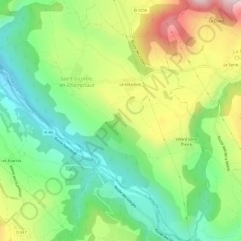
Name: Saint-Eusèbe-en-Champsaur topographic map, elevation, terrain.
Average elevation: 1,029 m
Minimum elevation: 856 m
Maximum elevation: 1,305 m
Other topographic maps
Click on a map to view its topography, its elevation and its terrain.
Le Villardon
France > Provence-Alpes-Côte d'Azur > Hautes-Alpes > Aubessagne
Le Villardon, Saint-Eusèbe-en-Champsaur, Aubessagne, Gap, Hautes-Alpes, Provence-Alpes-Côte d'Azur, Metropolitan France, 05500, France
Average elevation: 1,063 m