Geolocate

12th district topographic map

Interactive map

Click on the map to display elevation.

About this map

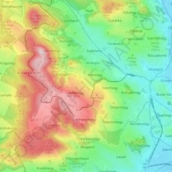
Name: 12th district topographic map, elevation, terrain.

Location: 12th district, Budapest, Central Hungary, Hungary (47.47609 18.92690 47.53359 19.03040)

Average elevation: 267 m

Minimum elevation: 106 m

Maximum elevation: 513 m

Other topographic maps

Click on a map to view its topography, its elevation and its terrain.

2nd district

Hungary > Budapest

2nd district, Budapest, Central Hungary, Hungary

Average elevation: 252 m

Budapest

Hungary > Budapest

Budapest, Central Hungary, Hungary

Average elevation: 153 m

Danube

Hungary > Budapest

Danube, Budapest, Central Hungary, 1036, Hungary

Average elevation: 114 m