
源城区 topographic map
Interactive map
Click on the map to display elevation.
About this map
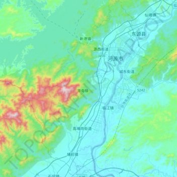
Name: 源城区 topographic map, elevation, terrain.
Location: 源城区, 河源市, 广东省, 中国 (23.53109 114.52360 23.85133 114.76215)
Average elevation: 173 m
Minimum elevation: 21 m
Maximum elevation: 1,042 m
源城区境内大部分处于河源盆地内,北部为东江和新丰江冲积而成的东埔小平原,中部为丘陵,南部为东江冲积而成的埔前小盆地,西部为山区。源城区总的地形地势为东低西高,南北低中间高。东江、新丰江、埔前河、七磜河、香车河等河流流经源城境内,全境属于珠江流域。
Other topographic maps
Click on a map to view its topography, its elevation and its terrain.