
Navenby topographic map
Interactive map
Click on the map to display elevation.
About this map
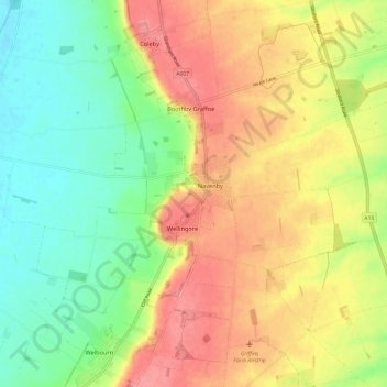
Name: Navenby topographic map, elevation, terrain.
Location: Navenby, North Kesteven, Lincolnshire, England, United Kingdom (53.08856 -0.60483 53.12177 -0.48584)
Average elevation: 47 m
Minimum elevation: 6 m
Maximum elevation: 91 m
Other topographic maps
Click on a map to view its topography, its elevation and its terrain.
Coleby
United Kingdom > England > Lincolnshire > North Kesteven
Coleby, North Kesteven, Lincolnshire, England, LN5 0AG, United Kingdom
Average elevation: 50 m
Norton Disney
United Kingdom > England > Lincolnshire > North Kesteven
Norton Disney, North Kesteven, Lincolnshire, England, United Kingdom
Average elevation: 17 m
Sleaford
United Kingdom > England > Lincolnshire > North Kesteven
Sleaford, North Kesteven, Lincolnshire, England, United Kingdom
Average elevation: 18 m
North Hykeham
United Kingdom > England > Lincolnshire > North Kesteven
North Hykeham, North Kesteven, Lincolnshire, England, United Kingdom
Average elevation: 12 m