
Galegos topographic map
Interactive map
Click on the map to display elevation.
About this map
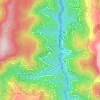
Name: Galegos topographic map, elevation, terrain.
Location: Galegos, Riotorto, Meira, Lugo, Galicia, 27744, España (43.24367 -7.23049 43.28367 -7.19049)
Average elevation: 412 m
Minimum elevation: 149 m
Maximum elevation: 724 m
Other topographic maps
Click on a map to view its topography, its elevation and its terrain.