
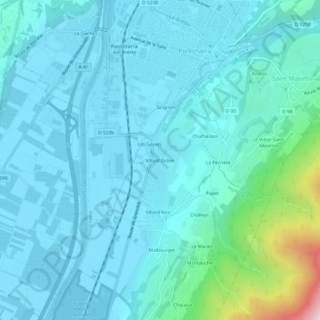
Villard Didier topographic map
Interactive map
Click on the map to display elevation.
About this map
Name: Villard Didier topographic map, elevation, terrain.
Average elevation: 357 m
Minimum elevation: 238 m
Maximum elevation: 1,154 m
Other topographic maps
Click on a map to view its topography, its elevation and its terrain.
Villard Noir
France > Auvergne-Rhône-Alpes > Isère > Pontcharra
Villard Noir, Pontcharra, Grenoble, Isère, Auvergne-Rhône-Alpes, France métropolitaine, 38530, France
Average elevation: 402 m
Montaucher
France > Auvergne-Rhône-Alpes > Isère > Pontcharra
Montaucher, Pontcharra, Grenoble, Isère, Auvergne-Rhône-Alpes, France métropolitaine, 38530, France
Average elevation: 545 m
Villard-Benoit
France > Auvergne-Rhône-Alpes > Isère > Pontcharra
Villard-Benoit, Pontcharra, Grenoble, Isère, Auvergne-Rhône-Alpes, France métropolitaine, 38530, France
Average elevation: 326 m
Challeys
France > Auvergne-Rhône-Alpes > Isère > Pontcharra
Challeys, Pontcharra, Grenoble, Isère, Auvergne-Rhône-Alpes, France métropolitaine, 38530, France
Average elevation: 481 m