
Thank you for supporting this site ❤️
Make a donation
Make a donation
Gear up for your next adventure:
As an Amazon Associate, this site earns from qualifying purchases at no extra cost to you.
Mostaganem topographic map
Click on the map to display elevation.
Thank you for supporting this site ❤️
Make a donation
Make a donation
Gear up for your next adventure:
As an Amazon Associate, this site earns from qualifying purchases at no extra cost to you.
About this map
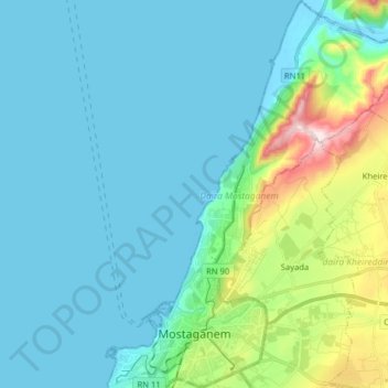
Name: Mostaganem topographic map, elevation, terrain.
Location: Mostaganem, Mostaganem district, Mostaganem, Algeria (35.91067 0.05362 36.03876 0.17673)
Average elevation: 68 m
Minimum elevation: -2 m
Maximum elevation: 399 m
Thank you for supporting this site ❤️
Make a donation
Make a donation
Gear up for your next adventure:
As an Amazon Associate, this site earns from qualifying purchases at no extra cost to you.