
Tapethok topographic map
Interactive map
Click on the map to display elevation.
About this map
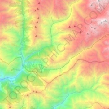
Name: Tapethok topographic map, elevation, terrain.
Location: Tapethok, Phaktanglung, ताप्लेजुङ, Province n°1, Népal (27.43166 87.73589 27.65892 88.00852)
Average elevation: 3,343 m
Minimum elevation: 1,283 m
Maximum elevation: 6,068 m
Other topographic maps
Click on a map to view its topography, its elevation and its terrain.
Kumbhakarna
Kumbhakarna, Lelep, Phaktanglung, ताप्लेजुङ, Province n°1, Népal
Average elevation: 6,415 m