Geolocate

Isabela topographic map

Click on the map to display elevation.

Isabela

The elevation of Isabela to 4th-class city status gave the local government a much-needed boost, efficiently delivered under the Biel administration, revitalized Isabela City, making it an engine of growth for Basilan province even as the hinterlands was wracked by incessant firefights and gun-battles between the military and bandit groups such as the Abu Sayyaf and Moro Islamic Liberation Front (MILF).

Wikipedia (CC-BY-SA 3.0)

About this map

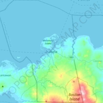
Name: Isabela topographic map, elevation, terrain.

Location: Isabela, Basilan, Zamboanga Peninsula, 7300, Philippines (6.56196 121.82248 6.84893 122.05996)

Average elevation: 93 m

Minimum elevation: -2 m

Maximum elevation: 915 m

Other topographic maps

Click on a map to view its topography, its elevation and its terrain.

Baluno

Philippines > Basilan

Average elevation: 27 m

Santa Clara

Philippines > Basilan > Isabela

Average elevation: 156 m

Sumagdang

Philippines > Basilan > Isabela

Average elevation: 25 m

Linawan

Philippines > Basilan > Tabuan-Lasa

Average elevation: 4 m

Kaumpurnah Zone 1

Philippines > Basilan > Isabela

Average elevation: 26 m

Kaumpurnah

Philippines > Basilan > Tabuan-Lasa

Average elevation: 2 m

Kaumpurnah Zone-3

Philippines > Basilan > Isabela

Average elevation: 26 m

Bagbagon

Philippines > Basilan > Lantawan

Average elevation: 7 m

Landugan

Philippines > Basilan > Lantawan

Average elevation: 45 m

Languyan

Philippines > Basilan > Hadji Mohammad Ajul

Average elevation: 79 m

Bato

Philippines > Basilan > Lamitan

Average elevation: 16 m

Parian-Baunoh

Philippines > Basilan > Lantawan

Average elevation: 20 m

Lawi-lawi

Philippines > Basilan > Lantawan

Average elevation: 32 m

Colonia

Philippines > Basilan > Lamitan

Average elevation: 38 m

Amaloy

Philippines > Basilan > Ungkaya Pukan

Average elevation: 62 m

Santa Clara

Philippines > Basilan > Lamitan

Average elevation: 157 m

Gear up for your next adventure:

🔭Compact Hiking Binoculars - Lightweight optics for scouting routes or birdwatching
🧥Down Jackets - Insulated jackets for cold weather
📚Map Reading & Navigation Guides - Master the art of interpreting topographic contours and symbols
🚴Cycling Backpacks - Backpacks for cyclists
🏃Compression Recovery Socks - Reduce leg fatigue after heavy days of elevation gain

As an Amazon Associate, this site earns from qualifying purchases at no extra cost to you.