
Dargov topographic map
Interactive map
Click on the map to display elevation.
About this map
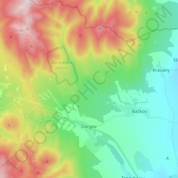
Name: Dargov topographic map, elevation, terrain.
Average elevation: 411 m
Minimum elevation: 139 m
Maximum elevation: 904 m
Other topographic maps
Click on a map to view its topography, its elevation and its terrain.
Boťany
Slovakia > Region of Košice > District of Trebišov
Boťany, District of Trebišov, Region of Košice, Eastern Slovakia, 076 43, Slovakia
Average elevation: 101 m
Dargov
Slovakia > Region of Košice > District of Trebišov > Dargov > Dargov
Dargov, District of Trebišov, Region of Košice, Eastern Slovakia, 076 61, Slovakia
Average elevation: 296 m
Boťany
Slovakia > Region of Košice > District of Trebišov > Boťany > Boťany
Boťany, District of Trebišov, Region of Košice, Eastern Slovakia, 076 43, Slovakia
Average elevation: 101 m