
Make a donation
Gear up for your next adventure:
As an Amazon Associate, this site earns from qualifying purchases at no extra cost to you.
Sungai Ampang topographic map
Click on the map to display elevation.
Make a donation
Gear up for your next adventure:
As an Amazon Associate, this site earns from qualifying purchases at no extra cost to you.
About this map
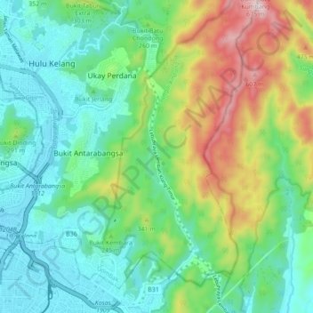
Name: Sungai Ampang topographic map, elevation, terrain.
Average elevation: 218 m
Minimum elevation: 43 m
Maximum elevation: 638 m
Make a donation
Gear up for your next adventure:
As an Amazon Associate, this site earns from qualifying purchases at no extra cost to you.
Other topographic maps
Click on a map to view its topography, its elevation and its terrain.
Make a donation
Gear up for your next adventure:
As an Amazon Associate, this site earns from qualifying purchases at no extra cost to you.
Make a donation
Gear up for your next adventure:
As an Amazon Associate, this site earns from qualifying purchases at no extra cost to you.
Hulu Kelang
Malaysia > Selangor > Ampang Jaya Municipal Council
It has an area of 16.94 square kilometres, and is located northeast of Kuala Lumpur. The surface is relatively high; 500 metres above sea level, and the topography here is highland, lowland, or undulating land. As a result, it is a rain catchment area for the Klang River. Among the high locations are Bukit…
Average elevation: 147 m
Air Terjun Empangan Tasik Hijau
Malaysia > Selangor > Ampang Jaya Municipal Council
Average elevation: 184 m
Make a donation
Gear up for your next adventure:
As an Amazon Associate, this site earns from qualifying purchases at no extra cost to you.
Kawasan Rekreasi AU2 Keramat
Malaysia > Selangor > Ampang Jaya Municipal Council
Average elevation: 74 m
Make a donation
Gear up for your next adventure:
As an Amazon Associate, this site earns from qualifying purchases at no extra cost to you.