
Make a donation
Gear up for your next adventure:
As an Amazon Associate, this site earns from qualifying purchases at no extra cost to you.
South Valley topographic map
Click on the map to display elevation.
Make a donation
Gear up for your next adventure:
As an Amazon Associate, this site earns from qualifying purchases at no extra cost to you.
About this map
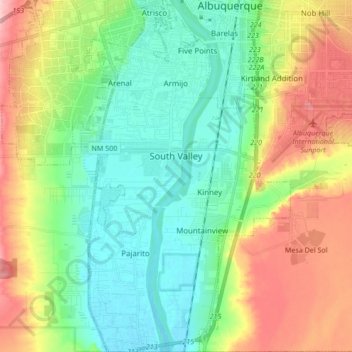
Name: South Valley topographic map, elevation, terrain.
Average elevation: 1,552 m
Minimum elevation: 1,492 m
Maximum elevation: 1,664 m
Make a donation
Gear up for your next adventure:
As an Amazon Associate, this site earns from qualifying purchases at no extra cost to you.
Other topographic maps
Click on a map to view its topography, its elevation and its terrain.
Eastrange-Piedra Vista
United States > New Mexico > Bernalillo County > Albuquerque
Average elevation: 1,839 m
Vista Del Mundo
United States > New Mexico > Bernalillo County > Albuquerque
Average elevation: 1,903 m
Sandia Heights
United States > New Mexico > Bernalillo County > Albuquerque
Average elevation: 1,898 m
Winterwood Park (HOA)
United States > New Mexico > Bernalillo County > Albuquerque
Average elevation: 1,770 m
Make a donation
Gear up for your next adventure:
As an Amazon Associate, this site earns from qualifying purchases at no extra cost to you.
Monte Largo Hills
United States > New Mexico > Bernalillo County > Albuquerque
Average elevation: 1,817 m
Glenwood Hills
United States > New Mexico > Bernalillo County > Albuquerque
Average elevation: 1,937 m
Make a donation
Gear up for your next adventure:
As an Amazon Associate, this site earns from qualifying purchases at no extra cost to you.
Joe M. Lucero Hillside
United States > New Mexico > Bernalillo County > Albuquerque
Average elevation: 1,637 m