
Make a donation
Gear up for your next adventure:
As an Amazon Associate, this site earns from qualifying purchases at no extra cost to you.
Harar topographic map
Click on the map to display elevation.
Make a donation
Gear up for your next adventure:
As an Amazon Associate, this site earns from qualifying purchases at no extra cost to you.
Harar
Harar is the capital city of the Harari Region. The ancient city is located on a hilltop in the eastern part of the country and is about five hundred kilometers from the Ethiopian capital Addis Ababa at an elevation of 1,885 metres (6,184 ft).
Make a donation
Gear up for your next adventure:
As an Amazon Associate, this site earns from qualifying purchases at no extra cost to you.
About this map
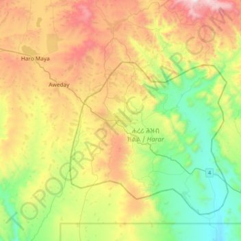
Name: Harar topographic map, elevation, terrain.
Location: Harar, Hareri, Harar, 3200, Ethiopia (9.15184 41.96844 9.47184 42.28844)
Average elevation: 1,837 m
Minimum elevation: 1,263 m
Maximum elevation: 2,739 m
Make a donation
Gear up for your next adventure:
As an Amazon Associate, this site earns from qualifying purchases at no extra cost to you.