
Make a donation
Gear up for your next adventure:
As an Amazon Associate, this site earns from qualifying purchases at no extra cost to you.
Argonne topographic map
Click on the map to display elevation.
Make a donation
Gear up for your next adventure:
As an Amazon Associate, this site earns from qualifying purchases at no extra cost to you.
Argonne
The Forest of Argonne (French pronunciation: [aʁɡɔn] ) is a long strip of mountainous and wild woodland in northeastern France, approximately 200 km (120 mi) east of Paris. The forest measures roughly 65 km (40 mi) long and 15 km (9 mi) wide filled with many small hills and deep valleys formed by water run-off from the Aire and Aisne rivers rarely exceeding more than 200 m (650 ft) in elevation. Following the First World War, the landscape of the forest was forever changed as trench warfare led to parts of the forest being riddled with deep human-made trenches along with craters from explosives. The forest is bordered by the Meuse River on the west and rolling farmland and creeks to the east. The forest is largely oak, chestnut, and pine trees, and ferns cover much of the forest floor. Common animal life consists of wild boar, red deer, roe deer, hares, rabbits, foxes, and wildcat.
Make a donation
Gear up for your next adventure:
As an Amazon Associate, this site earns from qualifying purchases at no extra cost to you.
About this map
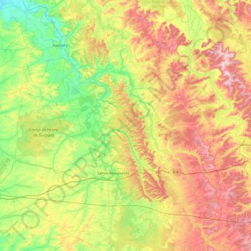
Name: Argonne topographic map, elevation, terrain.
Location: Argonne, Marne, Grand Est, Metropolitan France, France (48.90189 4.66237 49.50579 5.20653)
Average elevation: 197 m
Minimum elevation: 76 m
Maximum elevation: 388 m
Make a donation
Gear up for your next adventure:
As an Amazon Associate, this site earns from qualifying purchases at no extra cost to you.
Other topographic maps
Click on a map to view its topography, its elevation and its terrain.
Make a donation
Gear up for your next adventure:
As an Amazon Associate, this site earns from qualifying purchases at no extra cost to you.
Make a donation
Gear up for your next adventure:
As an Amazon Associate, this site earns from qualifying purchases at no extra cost to you.