
Make a donation
Gear up for your next adventure:
As an Amazon Associate, this site earns from qualifying purchases at no extra cost to you.
Ransel topographic map
Click on the map to display elevation.
Make a donation
Gear up for your next adventure:
As an Amazon Associate, this site earns from qualifying purchases at no extra cost to you.
Ransel
Ransel liegt auf einem Berg, nördlich und oberhalb von Lorch in etwa 400 Metern Höhe an der Landesgrenze von Hessen zu Rheinland-Pfalz. Der Ort ist umgeben von Wäldern. Die Landesstraße L 3397 führt in einer kurvenreichen Strecke durch das Tiefenbachtal hinab zur Kernstadt Lorch.
Make a donation
Gear up for your next adventure:
As an Amazon Associate, this site earns from qualifying purchases at no extra cost to you.
About this map
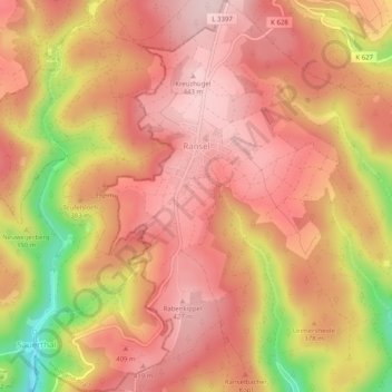
Name: Ransel topographic map, elevation, terrain.
Location: Ransel, Lorch, Rheingau-Taunus-Kreis, Hessen, Deutschland (50.08159 7.82982 50.11387 7.87354)
Average elevation: 366 m
Minimum elevation: 189 m
Maximum elevation: 448 m
Make a donation
Gear up for your next adventure:
As an Amazon Associate, this site earns from qualifying purchases at no extra cost to you.