
La Lomme topographic map
Interactive map
Click on the map to display elevation.
About this map
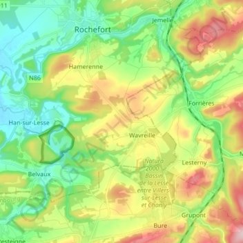
Name: La Lomme topographic map, elevation, terrain.
Average elevation: 243 m
Minimum elevation: 149 m
Maximum elevation: 403 m
Other topographic maps
Click on a map to view its topography, its elevation and its terrain.
Bure
België > Luxemburg > Neufchâteau > Tellin
Bure, Tellin, Neufchâteau, Luxemburg, Wallonië, België
Average elevation: 310 m