
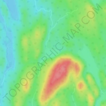
Lac Chanceux topographic map
Interactive map
Click on the map to display elevation.
About this map
Name: Lac Chanceux topographic map, elevation, terrain.
Average elevation: 588 m
Minimum elevation: 557 m
Maximum elevation: 644 m
Other topographic maps
Click on a map to view its topography, its elevation and its terrain.
Lac Poutrincourt
Canada > Québec > Le Domaine-du-Roy > Lac-Ashuapmushuan
Lac Poutrincourt, Lac-Ashuapmushuan, Le Domaine-du-Roy, Saguenay–Lac-Saint-Jean, Québec, Canada
Average elevation: 403 m
Lac aux Épaules
Canada > Québec > Le Domaine-du-Roy > Lac-Ashuapmushuan
Lac aux Épaules, Lac-Ashuapmushuan, Le Domaine-du-Roy, Saguenay–Lac-Saint-Jean, Québec, Canada
Average elevation: 518 m
Lac Priver
Canada > Québec > Le Domaine-du-Roy > Lac-Ashuapmushuan
Lac Priver, Lac-Ashuapmushuan, Le Domaine-du-Roy, Saguenay–Lac-Saint-Jean, Québec, Canada
Average elevation: 431 m
Lac Jonsac
Canada > Québec > Le Domaine-du-Roy > Lac-Ashuapmushuan
Lac Jonsac, Lac-Ashuapmushuan, Le Domaine-du-Roy, Saguenay–Lac-Saint-Jean, Québec, Canada
Average elevation: 462 m
Lac Mervent
Canada > Québec > Le Domaine-du-Roy > Lac-Ashuapmushuan
Lac Mervent, Lac-Ashuapmushuan, Le Domaine-du-Roy, Saguenay–Lac-Saint-Jean, Québec, Canada
Average elevation: 423 m