
River Road topographic map
Interactive map
Click on the map to display elevation.
About this map
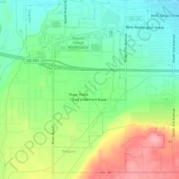
Name: River Road topographic map, elevation, terrain.
Location: River Road, Clallam County, Washington, United States (48.06148 -123.13503 48.07910 -123.11857)
Average elevation: 97 m
Minimum elevation: 53 m
Maximum elevation: 166 m
Other topographic maps
Click on a map to view its topography, its elevation and its terrain.
Dungeness Spit
United States > Washington > Clallam County > Old Town
Dungeness Spit, Old Town, Clallam County, Washington, United States
Average elevation: 3 m
Cake Rock
United States > Washington > Clallam County
Cake Rock, Clallam County, Washington, United States
Average elevation: 0 m
Ramapo
United States > Washington > Clallam County
Ramapo, Clallam County, Washington, United States
Average elevation: 114 m
Cape Flattery
United States > Washington > Clallam County
Cape Flattery, Clallam County, Washington, United States
Average elevation: 33 m
Port Angeles
United States > Washington > Clallam County
Port Angeles, Clallam County, Washington, 98362, United States
Average elevation: 27 m