Geolocate

Monticello topographic map

Click on the map to display elevation.

About this map
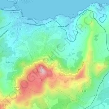
Name: Monticello topographic map, elevation, terrain.

Location: Monticello, Calvi, Haute-Corse, Corsica, Metropolitan France, 20220, France (42.60247 8.93482 42.64020 8.98779)

Average elevation: 109 m

Minimum elevation: -2 m

Maximum elevation: 393 m

Other topographic maps

Click on a map to view its topography, its elevation and its terrain.
Albertacce

France > Corsica > Haute-Corse > Albertacce > Albertacce

Average elevation: 996 m

Ghisoni

France > Corsica > Haute-Corse > Ghisoni > Ghisoni

Average elevation: 805 m

Cascade des Anglais

France > Corsica > Haute-Corse > Vivario

Average elevation: 1,329 m

Bergerie de Ballone

France > Corsica > Haute-Corse > Albertacce

Average elevation: 1,711 m

Calasima

France > Corsica > Haute-Corse > Calasima

Average elevation: 1,237 m

Gear up for your next adventure:

🧺Fast-Dry Microfiber Towels - Large towels that pack down to the size of an orange
🪢Paracord - Multi-purpose survival cord
🧭Global Orienteering Compass - High-precision liquid-filled compasses for accurate map reading and navigation
🧊Insulated Cooler Bags - Keep food fresh for day trips to remote geographic sites
🩹Blister Prevention Tape - Apply to friction points before they become painful sores

As an Amazon Associate, this site earns from qualifying purchases at no extra cost to you.