
Laramie topographic map
Interactive map
Click on the map to display elevation.
About this map
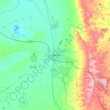
Name: Laramie topographic map, elevation, terrain.
Average elevation: 2,299 m
Minimum elevation: 2,133 m
Maximum elevation: 2,744 m
Other topographic maps
Click on a map to view its topography, its elevation and its terrain.
Laramie
États-Unis d'Amérique > Wyoming > Albany County > Laramie
Laramie, Albany County, Wyoming, États-Unis d'Amérique
Average elevation: 2,219 m