
Chard topographic map
Click on the map to display elevation.
Chard
Chard is a town and a civil parish in the English county of Somerset. It lies on the A30 road near the Devon and Dorset borders, 15 miles (24 km) south west of Yeovil. The parish has a population of approximately 13,000 and, at an elevation of 121 metres (397 ft), Chard is the southernmost and one of the highest towns in Somerset. Administratively Chard forms part of the district of South Somerset.
About this map
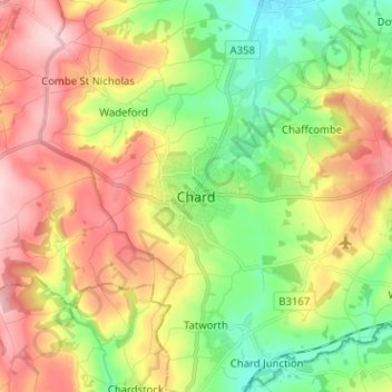
Name: Chard topographic map, elevation, terrain.
Location: Chard, Somerset, England, TA20 1FU, United Kingdom (50.83367 -2.99974 50.91367 -2.91974)
Average elevation: 135 m
Minimum elevation: 41 m
Maximum elevation: 249 m
Other topographic maps
Click on a map to view its topography, its elevation and its terrain.
Quantock Hills National Landscape
United Kingdom > England > Somerset > Over Stowey
Average elevation: 116 m
Mells Park
United Kingdom > England > Somerset > Vobster
The architect Edwin Lutyens had known the Horners, and Mells Park, since 1896. In 1918 he unsuccessfully tried to persuade the Horners to rebuild Park House. However, Reginald McKenna, the chairman of Midland Bank, and formerly Home Secretary and Chancellor of the Exchequer under Asquith, was married to Pamela…
Average elevation: 134 m
Priddy
United Kingdom > England > Somerset
The village lies in a small hollow near the summit of the Mendip range of hills, at an elevation of nearly 1,000 feet (300 m) above sea-level, and has evidence of occupation since neolithic times. There are remains of lead mining activities and caves in the limestone beneath the village.
Average elevation: 206 m
Muchelney
United Kingdom > England > Somerset
Muchelney (/ˈmʌtʃəlni/) is a clustered village and civil parish in Somerset, England, extending for 3 kilometres (1.9 mi) from the south bank of the River Parrett and that has a clustered centre. This is 1 mile (1.6 km) south of Huish and Langport and 4 miles (6.4 km) south west of Somerton in the South…
Average elevation: 9 m
Brompton Ralph
United Kingdom > England > Somerset > Somerset West and Taunton
Average elevation: 224 m