
Cuenca topographic map
Click on the map to display elevation.
About this map
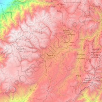
Name: Cuenca topographic map, elevation, terrain.
Location: Cuenca, Azuay, Ecuador (-3.17606 -79.62543 -2.55781 -78.84711)
Average elevation: 2,696 m
Minimum elevation: 9 m
Maximum elevation: 4,514 m
Other topographic maps
Click on a map to view its topography, its elevation and its terrain.
Cuenca
Cuenca, officially Santa Ana de los Ríos de Cuenca, is an Ecuadorian city, head of the canton of the same name and capital of the province of Azuay, as well as its largest and most populated city. It is crossed by the Tomebamba, Tarqui, Yanuncay and Machángara rivers, in the south-central inter-Andean region…
Average elevation: 2,973 m
Pallatanga
Ecuador > Azuay > Sevilla de Oro > Sevilla de Oro > Naute > Pallatanga
Average elevation: 2,500 m