
Make a donation
Gear up for your next adventure:
As an Amazon Associate, this site earns from qualifying purchases at no extra cost to you.
Chickaloon topographic map
Click on the map to display elevation.
Make a donation
Gear up for your next adventure:
As an Amazon Associate, this site earns from qualifying purchases at no extra cost to you.
About this map
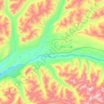
Name: Chickaloon topographic map, elevation, terrain.
Average elevation: 1,051 m
Minimum elevation: 182 m
Maximum elevation: 2,596 m
Make a donation
Gear up for your next adventure:
As an Amazon Associate, this site earns from qualifying purchases at no extra cost to you.
Other topographic maps
Click on a map to view its topography, its elevation and its terrain.
Skwentna
United States > Alaska > Matanuska-Susitna Borough
Hayes River is a weather station near Skwentna to the northeast, at an elevation of 1,000 feet (300 m). Hayes River also has a subarctic climate (Köppen Dfc) but has a lower seasonal temperature variation and receives substantially more snow.
Average elevation: 203 m
Willow
United States > Alaska > Matanuska-Susitna Borough
Willow has a subarctic climate with long and cold winters and mild summers. Whites Crossing is a weather station near Willow, situated at an elevation of 270 ft (82 m).
Average elevation: 69 m
Make a donation
Gear up for your next adventure:
As an Amazon Associate, this site earns from qualifying purchases at no extra cost to you.
Make a donation
Gear up for your next adventure:
As an Amazon Associate, this site earns from qualifying purchases at no extra cost to you.
Trapper Creek
United States > Alaska > Matanuska-Susitna Borough
Trapper Creek is a community located in Matanuska-Susitna Borough at latitude 62.317 and longitude -150.231, with an elevation of 351 ft (107 m). It is at mile 114.5 on the Parks Highway, just south of Denali State Park. Trapper Creek is found at the intersection of Petersville Road and is spread out along the…
Average elevation: 235 m
Make a donation
Gear up for your next adventure:
As an Amazon Associate, this site earns from qualifying purchases at no extra cost to you.
Make a donation
Gear up for your next adventure:
As an Amazon Associate, this site earns from qualifying purchases at no extra cost to you.