
Make a donation
Gear up for your next adventure:
As an Amazon Associate, this site earns from qualifying purchases at no extra cost to you.
Mekong topographic map
Click on the map to display elevation.
Make a donation
Gear up for your next adventure:
As an Amazon Associate, this site earns from qualifying purchases at no extra cost to you.
Mekong
The elevation of the Tibetan Plateau during the Tertiary period was an important factor in the genesis of the south-west monsoon, which is the dominant climatic control influencing the hydrology of the Mekong Basin. Understanding the nature and timing of the elevation of Tibet (and the Central Highlands of Vietnam) therefore helps explain the provenance of sediment reaching the delta and the Tonle Sap Great Lake today. Studies of the provenance of sediments in the Mekong delta reveal a major switch in the source of sediments about eight million years ago (Ma). From 36 to 8 Ma the bulk (76%) of the sediments deposited in the delta came from erosion of the bedrock in the Three Rivers Area. From 8 Ma to the present, however, the contribution from the Three Rivers Area fell to 40%, while that from the Central Highlands rose from 11 to 51%. One of the most striking conclusions of provenance studies is the small contribution of sediment from the other parts of the Mekong basin, notably the Khorat Plateau, the uplands of northern Laos and northern Thailand, and the mountain ranges south of the Three Rivers area.
Make a donation
Gear up for your next adventure:
As an Amazon Associate, this site earns from qualifying purchases at no extra cost to you.
About this map
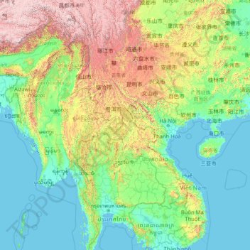
Name: Mekong topographic map, elevation, terrain.
Location: Mekong, Laos (10.27357 97.17769 31.13305 106.13706)
Average elevation: 795 m
Minimum elevation: -3 m
Maximum elevation: 6,545 m
Make a donation
Gear up for your next adventure:
As an Amazon Associate, this site earns from qualifying purchases at no extra cost to you.
Other topographic maps
Click on a map to view its topography, its elevation and its terrain.
B. Haysok
Laos > Vientiane Prefecture > Chanthabuly District > Vientiane Capital
Average elevation: 170 m
Make a donation
Gear up for your next adventure:
As an Amazon Associate, this site earns from qualifying purchases at no extra cost to you.
Make a donation
Gear up for your next adventure:
As an Amazon Associate, this site earns from qualifying purchases at no extra cost to you.
Make a donation
Gear up for your next adventure:
As an Amazon Associate, this site earns from qualifying purchases at no extra cost to you.
Saphangmo
Laos > Vientiane Prefecture > Xaysetha District > Vientiane Capital
Average elevation: 170 m
Donnokkhoum
Laos > Vientiane Prefecture > Sisattanak District > Vientiane Capital
Average elevation: 170 m
Phonsinouan
Laos > Vientiane Prefecture > Sisattanak District > Vientiane Capital
Average elevation: 170 m
Make a donation
Gear up for your next adventure:
As an Amazon Associate, this site earns from qualifying purchases at no extra cost to you.
Make a donation
Gear up for your next adventure:
As an Amazon Associate, this site earns from qualifying purchases at no extra cost to you.
Nongtaeng
Laos > Vientiane Prefecture > Sikhottabong District > Vientiane Capital
Average elevation: 174 m
Dongkhamxang
Laos > Vientiane Prefecture > Hadxayfong District > Vientiane Capital
Average elevation: 172 m
Make a donation
Gear up for your next adventure:
As an Amazon Associate, this site earns from qualifying purchases at no extra cost to you.
Nonghai
Laos > Vientiane Prefecture > Hadxayfong District > Vientiane Capital
Average elevation: 172 m
Muangvatha
Laos > Vientiane Prefecture > Sikhottabong District > Vientiane Capital
Average elevation: 169 m
Make a donation
Gear up for your next adventure:
As an Amazon Associate, this site earns from qualifying purchases at no extra cost to you.
Dognaxoyneua
Laos > Vientiane Prefecture > Sikhottabong District > Vientiane Capital
Average elevation: 169 m
ທົ່ງປົງ
Laos > Vientiane Prefecture > Sikhottabong District > Vientiane Capital
Average elevation: 174 m
Make a donation
Gear up for your next adventure:
As an Amazon Associate, this site earns from qualifying purchases at no extra cost to you.
Nongtha Marsh
Laos > Vientiane Prefecture > Chanthabuly District > Vientiane Capital > B. Nongthanua
Average elevation: 175 m
Don Koy
Laos > Vientiane Prefecture > Sisattanak District > Vientiane Capital
Average elevation: 169 m
Make a donation
Gear up for your next adventure:
As an Amazon Associate, this site earns from qualifying purchases at no extra cost to you.
Chommanytai
Laos > Vientiane Prefecture > Xaysetha District > Vientiane Capital
Average elevation: 172 m
Make a donation
Gear up for your next adventure:
As an Amazon Associate, this site earns from qualifying purchases at no extra cost to you.
Make a donation
Gear up for your next adventure:
As an Amazon Associate, this site earns from qualifying purchases at no extra cost to you.
Make a donation
Gear up for your next adventure:
As an Amazon Associate, this site earns from qualifying purchases at no extra cost to you.
Dongphosy
Laos > Vientiane Prefecture > Hadxayfong District > Vientiane Capital
Average elevation: 168 m
Make a donation
Gear up for your next adventure:
As an Amazon Associate, this site earns from qualifying purchases at no extra cost to you.
Make a donation
Gear up for your next adventure:
As an Amazon Associate, this site earns from qualifying purchases at no extra cost to you.
Make a donation
Gear up for your next adventure:
As an Amazon Associate, this site earns from qualifying purchases at no extra cost to you.
Make a donation
Gear up for your next adventure:
As an Amazon Associate, this site earns from qualifying purchases at no extra cost to you.
Make a donation
Gear up for your next adventure:
As an Amazon Associate, this site earns from qualifying purchases at no extra cost to you.
Thatlouangkang
Laos > Vientiane Prefecture > Xaysetha District > Vientiane Capital
Average elevation: 170 m
Make a donation
Gear up for your next adventure:
As an Amazon Associate, this site earns from qualifying purchases at no extra cost to you.
Make a donation
Gear up for your next adventure:
As an Amazon Associate, this site earns from qualifying purchases at no extra cost to you.
Make a donation
Gear up for your next adventure:
As an Amazon Associate, this site earns from qualifying purchases at no extra cost to you.
Make a donation
Gear up for your next adventure:
As an Amazon Associate, this site earns from qualifying purchases at no extra cost to you.
Make a donation
Gear up for your next adventure:
As an Amazon Associate, this site earns from qualifying purchases at no extra cost to you.
Sibounheuang
Laos > Vientiane Prefecture > Chanthabuly District > Sibounheuang
Average elevation: 171 m
Xiangkhouang
Xiangkhouang province covers an area of 15,880 square kilometres (6,130 sq mi) and is mountainous. Apart from floodplains, the largest area of level land in the country is on the province's Xiangkhoang Plateau. The plateau is characterized by rolling hills and grassland whose elevation averages 1,300 metres…
Average elevation: 565 m
Make a donation
Gear up for your next adventure:
As an Amazon Associate, this site earns from qualifying purchases at no extra cost to you.
Make a donation
Gear up for your next adventure:
As an Amazon Associate, this site earns from qualifying purchases at no extra cost to you.
Make a donation
Gear up for your next adventure:
As an Amazon Associate, this site earns from qualifying purchases at no extra cost to you.