
Thank you for supporting this site ❤️
Make a donation
Make a donation
Gear up for your next adventure:
As an Amazon Associate, this site earns from qualifying purchases at no extra cost to you.
Thakhek topographic map
Click on the map to display elevation.
Thank you for supporting this site ❤️
Make a donation
Make a donation
Gear up for your next adventure:
As an Amazon Associate, this site earns from qualifying purchases at no extra cost to you.
About this map
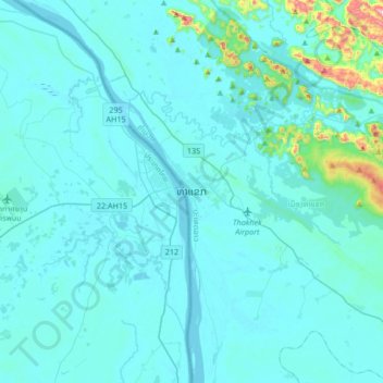
Name: Thakhek topographic map, elevation, terrain.
Location: Thakhek, Thakhek District, Khammouane, 12000, Laos (17.23462 104.64645 17.55462 104.96645)
Average elevation: 179 m
Minimum elevation: 133 m
Maximum elevation: 779 m
Thank you for supporting this site ❤️
Make a donation
Make a donation
Gear up for your next adventure:
🧊Insulated Stainless Steel Flasks - Keep water cold for 24 hours in the heat or coffee hot in the cold
🐍Australian Snake Bite Kits - Specific pressure immobilization bandages for Australian venomous snakes
As an Amazon Associate, this site earns from qualifying purchases at no extra cost to you.