
Thank you for supporting this site ❤️
Make a donation
Make a donation
Gear up for your next adventure:
As an Amazon Associate, this site earns from qualifying purchases at no extra cost to you.
Söödi topographic map
Click on the map to display elevation.
Thank you for supporting this site ❤️
Make a donation
Make a donation
Gear up for your next adventure:
As an Amazon Associate, this site earns from qualifying purchases at no extra cost to you.
About this map
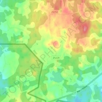
Name: Söödi topographic map, elevation, terrain.
Location: Söödi, Söödi küla, Rõuge vald, Võru maakond, 65195, Estonia (57.58174 27.03070 57.62174 27.07070)
Average elevation: 208 m
Minimum elevation: 169 m
Maximum elevation: 259 m
Thank you for supporting this site ❤️
Make a donation
Make a donation
Gear up for your next adventure:
As an Amazon Associate, this site earns from qualifying purchases at no extra cost to you.