Geolocate

Mendlesham topographic map

Click on the map to display elevation.

About this map

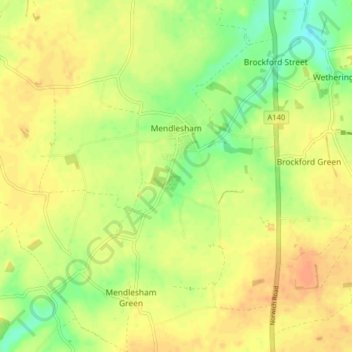
Name: Mendlesham topographic map, elevation, terrain.

Location: Mendlesham, Mid Suffolk, Suffolk, England, United Kingdom (52.21985 1.04127 52.26871 1.10288)

Average elevation: 57 m

Minimum elevation: 36 m

Maximum elevation: 71 m

Other topographic maps

Click on a map to view its topography, its elevation and its terrain.

Forward Green

United Kingdom > England > Suffolk > Mid Suffolk

Average elevation: 55 m

Eye Castle

United Kingdom > England > Suffolk > Mid Suffolk > Eye

Average elevation: 39 m

Haughley Green

United Kingdom > England > Suffolk > Mid Suffolk

Average elevation: 61 m

Brome

United Kingdom > England > Suffolk > Mid Suffolk

Average elevation: 40 m

Earl Stonham

United Kingdom > England > Suffolk > Mid Suffolk

Average elevation: 55 m

Rickinghall

United Kingdom > England > Suffolk > Mid Suffolk

Average elevation: 46 m

Needham Lake

United Kingdom > England > Suffolk > Mid Suffolk

Average elevation: 33 m

Mill Green

United Kingdom > England > Suffolk > Mid Suffolk

Average elevation: 60 m

Old Newton

United Kingdom > England > Suffolk > Mid Suffolk

Average elevation: 56 m

Borley Green

United Kingdom > England > Suffolk > Mid Suffolk > Woolpit

Average elevation: 62 m

Woolpit Green

United Kingdom > England > Suffolk > Mid Suffolk > Woolpit

Average elevation: 64 m

Winston Green

United Kingdom > England > Suffolk > Mid Suffolk

Average elevation: 53 m

Pixey Green

United Kingdom > England > Suffolk > Mid Suffolk

Average elevation: 50 m

Gear up for your next adventure:

🎨Portable Watercolor Kits - Paint the landscapes and topographic views you discover
Altimeter Watches - Watches with altitude tracking
🦟Heavy Duty Insect Repellent - Essential protection against flies, mozzies, and march flies
🥶Thermal Beanies - Warm hats for cold hikes
🎒Daypacks - Compact backpacks for short hikes

As an Amazon Associate, this site earns from qualifying purchases at no extra cost to you.