
Make a donation
Gear up for your next adventure:
As an Amazon Associate, this site earns from qualifying purchases at no extra cost to you.
Wilsdruff topographic map
Click on the map to display elevation.
Make a donation
Gear up for your next adventure:
As an Amazon Associate, this site earns from qualifying purchases at no extra cost to you.
About this map
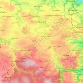
Name: Wilsdruff topographic map, elevation, terrain.
Average elevation: 303 m
Minimum elevation: 127 m
Maximum elevation: 437 m
Make a donation
Gear up for your next adventure:
As an Amazon Associate, this site earns from qualifying purchases at no extra cost to you.
Other topographic maps
Click on a map to view its topography, its elevation and its terrain.
Reinhardtsgrimma
Germany > Saxony > Sächsische Schweiz-Osterzgebirge > Glashütte
Average elevation: 372 m
Make a donation
Gear up for your next adventure:
As an Amazon Associate, this site earns from qualifying purchases at no extra cost to you.
Saxon Switzerland
Germany > Saxony > Sächsische Schweiz-Osterzgebirge
Saxon Switzerland forms the northern part of the Elbe Sandstone Mountains range, located on the German-Czech border. To the east, it transitions into the Lusatian Highlands and, to the west, into the Ore Mountains. The Czech part of the Elbe Sandstone Mountains is partly formed by the Bohemian Switzerland…
Average elevation: 341 m
Berreuth
Germany > Saxony > Sächsische Schweiz-Osterzgebirge > Dippoldiswalde
Average elevation: 388 m
Make a donation
Gear up for your next adventure:
As an Amazon Associate, this site earns from qualifying purchases at no extra cost to you.
Topograph
Germany > Saxony > Sächsische Schweiz-Osterzgebirge > Rosenthal-Bielatal
Average elevation: 385 m
Diebskeller
Germany > Saxony > Sächsische Schweiz-Osterzgebirge > Königstein > Pfaffendorf > Hütten
Average elevation: 248 m
Siamesische Zwillinge, Dick
Germany > Saxony > Sächsische Schweiz-Osterzgebirge > Bad Schandau
Average elevation: 366 m
Make a donation
Gear up for your next adventure:
As an Amazon Associate, this site earns from qualifying purchases at no extra cost to you.