Geolocate

Talacogon topographic map

Click on the map to display elevation.

About this map

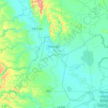
Name: Talacogon topographic map, elevation, terrain.

Location: Talacogon, Agusan del Sur, Caraga, 8510, Philippines (8.31924 125.59054 8.53458 125.89536)

Average elevation: 41 m

Minimum elevation: 6 m

Maximum elevation: 221 m

Other topographic maps

Click on a map to view its topography, its elevation and its terrain.

Wawa Dam

Philippines > Agusan del Sur > Bayugan > Wawa

Average elevation: 78 m

Binucayan

Philippines > Agusan del Sur > Binucayan

Average elevation: 48 m

Magsaysay

Philippines > Agusan del Sur

Average elevation: 208 m

Gear up for your next adventure:

🔪Outdoor Multi-tools - Versatile tools for gear repair and survival tasks in the wilderness
🧼Biodegradable Outdoor Soap - Clean gear and yourself without harming the local ecosystem
🆘Personal Locator Beacons (PLB) - Satellite emergency beacons for life-saving help in areas with no mobile coverage
🧥Down Jackets - Insulated jackets for cold weather
🛰️Handheld GPS Units - Rugged GPS devices for tracking coordinates and elevation in the Australian bush

As an Amazon Associate, this site earns from qualifying purchases at no extra cost to you.