Finedon topographic map
Interactive map
Click on the map to display elevation.
About this map
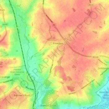
Name: Finedon topographic map, elevation, terrain.
Location: Finedon, North Northamptonshire, England, United Kingdom (52.31263 -0.68627 52.36156 -0.62272)
Average elevation: 75 m
Minimum elevation: 34 m
Maximum elevation: 100 m
The town of Finedon rises to approximately 90 metres Above Ordinance Datum from the River Ise, with the historical centre of the settlement occupying a shallow south-west facing valley. The contemporary point of maximum elevation in the parish is the summit of the disused Sidegate Lane Landfill Site, located south of the town at approximately 108 metres Above Ordinance Datum. The parish covers a total area of 1,482 hectares (3,662 acres).
Other topographic maps
Click on a map to view its topography, its elevation and its terrain.
Corby
United Kingdom > England > North Northamptonshire > Corby
Corby, North Northamptonshire, East Midlands, England, United Kingdom
Average elevation: 98 m
Mears Ashby
United Kingdom > England > North Northamptonshire
Mears Ashby, North Northamptonshire, England, United Kingdom
Average elevation: 107 m
Lowick
United Kingdom > England > North Northamptonshire
Lowick, North Northamptonshire, England, NN14 3BH, United Kingdom
Average elevation: 57 m
Wadenhoe
United Kingdom > England > North Northamptonshire
Wadenhoe, North Northamptonshire, England, PE8 5SX, United Kingdom
Average elevation: 48 m
Irchester Country Park
United Kingdom > England > North Northamptonshire > Little Irchester
Irchester Country Park, Little Irchester, Irchester, North Northamptonshire, England, NN29 7DL, United Kingdom
Average elevation: 60 m
Great Addington
United Kingdom > England > North Northamptonshire
Great Addington, North Northamptonshire, England, United Kingdom
Average elevation: 60 m
Little Stanion
United Kingdom > England > North Northamptonshire
Little Stanion, North Northamptonshire, England, NN18 8GY, United Kingdom
Average elevation: 97 m
Dingley
United Kingdom > England > North Northamptonshire
Dingley, North Northamptonshire, England, LE16 8PG, United Kingdom
Average elevation: 110 m
Geddington
United Kingdom > England > North Northamptonshire
Geddington, North Northamptonshire, England, United Kingdom
Average elevation: 97 m
Laxton
United Kingdom > England > North Northamptonshire
Laxton, North Northamptonshire, England, NN17 3AY, United Kingdom
Average elevation: 86 m
Aldwincle
United Kingdom > England > North Northamptonshire
Aldwincle, North Northamptonshire, England, NN14 3UU, United Kingdom
Average elevation: 44 m
Brigstock
United Kingdom > England > North Northamptonshire
Brigstock, North Northamptonshire, England, NN14 3HG, United Kingdom
Average elevation: 79 m
Great Doddington
United Kingdom > England > North Northamptonshire
Great Doddington, North Northamptonshire, England, United Kingdom
Average elevation: 64 m
Titchmarsh
United Kingdom > England > North Northamptonshire
Titchmarsh, North Northamptonshire, England, NN14 3DJ, United Kingdom
Average elevation: 45 m
East Carlton
United Kingdom > England > North Northamptonshire
East Carlton, North Northamptonshire, England, LE16 8YG, United Kingdom
Average elevation: 101 m
Sywell
United Kingdom > England > North Northamptonshire
Sywell, North Northamptonshire, England, United Kingdom
Average elevation: 113 m
Hardwick
United Kingdom > England > North Northamptonshire
Hardwick, North Northamptonshire, England, United Kingdom
Average elevation: 110 m
Corby
United Kingdom > England > North Northamptonshire
Corby, North Northamptonshire, England, United Kingdom
Average elevation: 109 m
Braybrooke
United Kingdom > England > North Northamptonshire
Braybrooke, North Northamptonshire, England, LE16 8LQ, United Kingdom
Average elevation: 123 m
Hargrave
United Kingdom > England > North Northamptonshire
Hargrave, North Northamptonshire, England, NN9 6BW, United Kingdom
Average elevation: 70 m
Wellingborough
United Kingdom > England > North Northamptonshire
Wellingborough, North Northamptonshire, England, NN8 1AF, United Kingdom
Average elevation: 76 m
Weekley
United Kingdom > England > North Northamptonshire
Weekley, North Northamptonshire, England, NN16 9UP, United Kingdom
Average elevation: 92 m
Kettering
United Kingdom > England > North Northamptonshire
Kettering, North Northamptonshire, England, United Kingdom
Average elevation: 88 m
Glapthorn
United Kingdom > England > North Northamptonshire
Glapthorn, North Northamptonshire, England, PE8 5BE, United Kingdom
Average elevation: 49 m
Rushden
United Kingdom > England > North Northamptonshire
Rushden, North Northamptonshire, England, United Kingdom
Average elevation: 77 m
Irchester
United Kingdom > England > North Northamptonshire
Irchester, North Northamptonshire, England, United Kingdom
Average elevation: 62 m
Thrapston
United Kingdom > England > North Northamptonshire
Thrapston, North Northamptonshire, England, United Kingdom
Average elevation: 47 m
Irthlingborough
United Kingdom > England > North Northamptonshire
Irthlingborough, North Northamptonshire, England, United Kingdom
Average elevation: 66 m
Twywell
United Kingdom > England > North Northamptonshire
Twywell, North Northamptonshire, England, NN14 3AH, United Kingdom
Average elevation: 71 m
Oundle
United Kingdom > England > North Northamptonshire
Oundle, North Northamptonshire, England, United Kingdom
Average elevation: 37 m
Earls Barton
United Kingdom > England > North Northamptonshire > Earls Barton
Earls Barton, North Northamptonshire, England, United Kingdom
Average elevation: 70 m
Raunds
United Kingdom > England > North Northamptonshire
Raunds, North Northamptonshire, England, United Kingdom
Average elevation: 65 m
Desborough
United Kingdom > England > North Northamptonshire
Desborough, North Northamptonshire, England, United Kingdom
Average elevation: 126 m
Ringstead
United Kingdom > England > North Northamptonshire > Ringstead
Ringstead, North Northamptonshire, East Midlands, England, NN14 4DA, United Kingdom
Average elevation: 53 m
Rothwell
United Kingdom > England > North Northamptonshire
Rothwell, North Northamptonshire, England, United Kingdom
Average elevation: 117 m
Woodford
United Kingdom > England > North Northamptonshire > Woodford
Woodford, North Northamptonshire, East Midlands, England, NN14 4HB, United Kingdom
Average elevation: 55 m
Burton Latimer
United Kingdom > England > North Northamptonshire > Burton Latimer
Burton Latimer, North Northamptonshire, England, United Kingdom
Average elevation: 79 m
Higham Ferrers
United Kingdom > England > North Northamptonshire
Higham Ferrers, North Northamptonshire, England, United Kingdom
Average elevation: 62 m
Slade
United Kingdom > England > North Northamptonshire > Orton
Slade, Orton, North Northamptonshire, East Midlands, England, NN14, United Kingdom
Average elevation: 123 m
Wollaston
United Kingdom > England > North Northamptonshire
Wollaston, North Northamptonshire, England, United Kingdom
Average elevation: 72 m
Warmington
United Kingdom > England > North Northamptonshire
Warmington, North Northamptonshire, England, United Kingdom
Average elevation: 39 m
Fotheringhay
United Kingdom > England > North Northamptonshire
Fotheringhay, North Northamptonshire, England, United Kingdom
Average elevation: 26 m
Rushton
United Kingdom > England > North Northamptonshire
Rushton, North Northamptonshire, England, NN14 1RJ, United Kingdom
Average elevation: 112 m
Little Addington
United Kingdom > England > North Northamptonshire
Little Addington, North Northamptonshire, England, United Kingdom
Average elevation: 59 m
Collyweston
United Kingdom > England > North Northamptonshire
Collyweston, North Northamptonshire, England, PE9 3PQ, United Kingdom
Average elevation: 66 m
Wilbarston
United Kingdom > England > North Northamptonshire
Wilbarston, North Northamptonshire, England, LE16 8QP, United Kingdom
Average elevation: 107 m
Weldon
United Kingdom > England > North Northamptonshire
Weldon, North Northamptonshire, England, United Kingdom
Average elevation: 98 m
Stanwick
United Kingdom > England > North Northamptonshire > Raunds
Stanwick, Raunds, North Northamptonshire, England, United Kingdom
Average elevation: 53 m
Grafton Underwood
United Kingdom > England > North Northamptonshire
Grafton Underwood, North Northamptonshire, England, NN14 3AA, United Kingdom
Average elevation: 95 m
Pytchley
United Kingdom > England > North Northamptonshire
Pytchley, North Northamptonshire, England, NN14 1EN, United Kingdom
Average elevation: 90 m