
Make a donation
Gear up for your next adventure:
As an Amazon Associate, this site earns from qualifying purchases at no extra cost to you.
The Blue Mountains topographic map
Click on the map to display elevation.
Make a donation
Gear up for your next adventure:
As an Amazon Associate, this site earns from qualifying purchases at no extra cost to you.
About this map
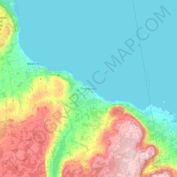
Name: The Blue Mountains topographic map, elevation, terrain.
Location: The Blue Mountains, Grey County, Ontario, N0H 2P0, Canada (44.40170 -80.61011 44.72170 -80.29011)
Average elevation: 265 m
Minimum elevation: 173 m
Maximum elevation: 531 m
Make a donation
Gear up for your next adventure:
As an Amazon Associate, this site earns from qualifying purchases at no extra cost to you.
Other topographic maps
Click on a map to view its topography, its elevation and its terrain.
Craigleith Provincial Park
Canada > Ontario > Grey County > The Blue Mountains
Average elevation: 215 m
Make a donation
Gear up for your next adventure:
As an Amazon Associate, this site earns from qualifying purchases at no extra cost to you.