
Mount Blanc topographic map
Interactive map
Click on the map to display elevation.
About this map
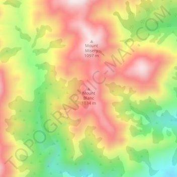
Name: Mount Blanc topographic map, elevation, terrain.
Location: Mount Blanc, Marlborough, New Zealand (-41.88463 173.86744 -41.88453 173.86754)
Average elevation: 823 m
Minimum elevation: 518 m
Maximum elevation: 1,079 m
Other topographic maps
Click on a map to view its topography, its elevation and its terrain.
Rakiura Rocks
New Zealand > Marlborough > Marlborough District
Rakiura Rocks, Marlborough District, Marlborough, New Zealand
Average elevation: 10 m
Devils Backbone
Devils Backbone, Marlborough, New Zealand
Average elevation: 806 m
Blenheim
New Zealand > Marlborough > Blenheim
Blenheim, Marlborough, 7301, New Zealand
Average elevation: 20 m
Duncan Bay
New Zealand > Marlborough > Duncan Bay
Duncan Bay, Marlborough, New Zealand
Average elevation: 173 m
Awatere River
Awatere River, Marlborough, 7210, New Zealand
Average elevation: 636 m