
Perast topographic map
Interactive map
Click on the map to display elevation.
About this map
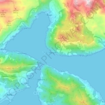
Name: Perast topographic map, elevation, terrain.
Location: Perast, Municipalité de Kotor, 85336, Monténégro (42.44627 18.65886 42.52627 18.73886)
Average elevation: 281 m
Minimum elevation: -2 m
Maximum elevation: 1,269 m
Other topographic maps
Click on a map to view its topography, its elevation and its terrain.
Kotor
Monténégro > Municipalité de Kotor
Kotor, Municipalité de Kotor, 85339, Monténégro
Average elevation: 280 m