
Make a donation
Gear up for your next adventure:
As an Amazon Associate, this site earns from qualifying purchases at no extra cost to you.
Ruaudin topographic map
Click on the map to display elevation.
Make a donation
Gear up for your next adventure:
As an Amazon Associate, this site earns from qualifying purchases at no extra cost to you.
Ruaudin
Ruaudin (French pronunciation: [ʁɥodɛ̃]) is a commune in the department of Sarthe in the Pays de la Loire Region of north-western France. Ruaudin is located in the canton of Écommoy and the arrondissement of Le Mans. The INSEE code is 72260 and the postal code is 72230. The minimum elevation is 47 meters and the maximum elevation is 66 meters. The town has a total surface area of 13.78 km2 (5.32 sq mi). The population of Ruaudin was 2,862 in 1999, 3,322 in 2007 and 3,418 in 2017. The nearest town from Ruaudin is Mulsanne, which is just 4.8 kilometers away. Ruaudin gained district hood in 1787. The village had 144 active establishments at the end of 2018. There were 22 documented births in 2019.
Make a donation
Gear up for your next adventure:
As an Amazon Associate, this site earns from qualifying purchases at no extra cost to you.
About this map
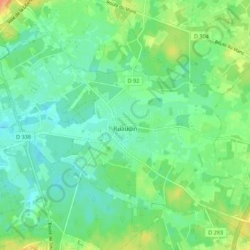
Name: Ruaudin topographic map, elevation, terrain.
Average elevation: 59 m
Minimum elevation: 46 m
Maximum elevation: 84 m
Make a donation
Gear up for your next adventure:
As an Amazon Associate, this site earns from qualifying purchases at no extra cost to you.
Other topographic maps
Click on a map to view its topography, its elevation and its terrain.