Geolocate

Asheridge topographic map

Click on the map to display elevation.

About this map

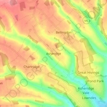
Name: Asheridge topographic map, elevation, terrain.

Location: Asheridge, Buckinghamshire, England, HP5 2UZ, United Kingdom (51.71036 -0.66101 51.75036 -0.62101)

Average elevation: 160 m

Minimum elevation: 106 m

Maximum elevation: 202 m

Other topographic maps

Click on a map to view its topography, its elevation and its terrain.

Denham

United Kingdom > England > Buckinghamshire

Average elevation: 56 m

Aylesbury

United Kingdom > England > Buckinghamshire

Aylesbury is immediately southeast of the upper River Thame that flows past Thame to Dorchester on Thames and is partly sited on the two northernmost outcrops of Portland (lime)stone in England bisected by a small stream, Bear Brook which gives a relatively prominent position in relation to the terrain of all…

Average elevation: 85 m

Waddesdon

United Kingdom > England > Buckinghamshire

Average elevation: 90 m

Swanbourne

United Kingdom > England > Buckinghamshire

Average elevation: 118 m

Buckland

United Kingdom > England > Buckinghamshire > Buckland

Average elevation: 131 m

Gear up for your next adventure:

🧥Packable Rain Jackets - Breathable waterproof layers for unpredictable mountain weather
🔦Powerful LED Headlamps - Hands-free lighting for night navigation and setting up camp after dark
🧺Fast-Dry Microfiber Towels - Large towels that pack down to the size of an orange
🔥Windproof Plasma Lighters - USB rechargeable lighters that work in high-altitude winds
🧥Thermal Emergency Blankets - Compact Mylar blankets to prevent hypothermia if stranded overnight

As an Amazon Associate, this site earns from qualifying purchases at no extra cost to you.