Geolocate

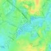
Trekroner topographic map

Click on the map to display elevation.

About this map

Name: Trekroner topographic map, elevation, terrain.

Location: Trekroner, København, Københavns Kommune, Region Hovedstaden, Danmark (55.70159 12.61160 55.70394 12.61533)

Average elevation: 0 m

Minimum elevation: -4 m

Maximum elevation: 8 m

Other topographic maps

Click on a map to view its topography, its elevation and its terrain.

Slotsholmen

Danmark > Region Hovedstaden > København

Average elevation: 6 m

Damhussøen

Danmark > Region Hovedstaden > København

Average elevation: 14 m

Gear up for your next adventure:

🔪Outdoor Multi-tools - Versatile tools for gear repair and survival tasks in the wilderness
🚁Camera Drones with GPS - Capture aerial views of the landscape to compare with topo maps
💡Collapsible Camping Lanterns - Illuminate your base camp or tent for map studying at night
📟Satellite Messengers - Two-way satellite communication to stay in touch beyond the cellular grid
🧤Thermal Hiking Gloves - Keep your hands warm and functional during high-altitude winter treks

As an Amazon Associate, this site earns from qualifying purchases at no extra cost to you.